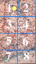
of map page C3
with 8 subdivisions.
The yellow dot
indicates the eastern
side of the subdivision 1.
On the full-size map
page the subdivisions are
separated by light blue lines.
| |
| A small-size image of map page C3 with 8 subdivisions. The yellow dot indicates the eastern side of the subdivision 1. On the full-size map page the subdivisions are separated by light blue lines. |
If the name crosses the subdivision boundary, the site is pointed out by the subdivision where the name is most easily read, and the subdivision number is followed by the letter r.
See abbreviations and explanations of Finnish terms at the end of this page.
 The directions are:
e = southern side of the indicated subdivision
i = eastern side of the indicated subdivision
ka = south-eastern side of the indicated subdivision
ke = central part of the indicated subdivision
ko = north-eastern side of the indicated subdivision
lo = south-western side of the indicated subdivision
lu = north-western side of the indicated subdivision
lä = western side of the indicated subdivision
p = northern side of the indicated subdivision, with
r = after subdivision number: the site is close to or on the subdivision boundary.
The position indicator for larger streams and lakes etc. shows the starting point of its name.
2. Distances (in km) are measured as rectilinear distances between localities.
3. For localities situated outside the Finnish borders, only St. Petersburg (Pietari) and the railways stations between that city and the Finnish border are listed in the index.
4. Localities and other places with identical names are indexed starting from north to south and from west to east.
5. Finnish and Swedish names. All the places that have commonly used distinct names both in Finnish and Swedish, the Swedish name is put in brackets. It is, however, listed also in the index with a link to the Finnish name. In case of farms and manors, the owners are consulted about their proper names whenever the usage is not well-known.
The author has not followed the established official guideline in listing the railway stations and post offices by either their Finnish or Swedish names depending on the number of speakers of Finnish or Swedish in each locality. The everyday usage by educated Finnish or Swedish speakers among the general public has guided the preferences in this book.
Both the Finnish and Swedish name is presented on the map for towns, parishes, rivers etc., if they exist. If the difference between the names is insignificant or otherwise clear, only one form is given. Farms and similar places hold names, which are used by their proprietors.
6. If a locality helds several or varied names, the author has set the priority to the most common one; others are mentioned if so appraised.
What names go for farms and industrial installations are determined by the usage of their owners. When in doubt, the question was settled by direct inquiries.
If there are variations in names, the compatible parts are replaced by a hyphen -, as in Elimä l. -mäki (= Elimä or Elimäki).
If letters are written inside square brackets [ ], the form without those letters is preferrable.
2. Towns (kaupunki) and market towns (kauppala). The data include population figures according to church registry (kirkonkirj.) and census lists (henkikirj.), the number of speakers of Finnish (suom.) and Swedish (ruots.), government offices (customs houses and municipal offices are not included), educational institutions (Oppilait.), banks (Pankkeja), military units, public hospitals, prisons, market days and animal markets, veterinarians, telegraph offices, societies and associations excluding societies with a purely local interest (agricultural societies etc. are commonly noted), parks, important buildings, main historical events etc. A Russian church can be found in towns with a Greek-Russian deanery. Post offices and a municipal medical officer, which can be found in most towns, are not mentioned, if lacking, a remark is given.
3. Rural municipalities, parishes; in the articles starting with a name printed in bold, the following information is presented:
a) the jurisdictional, police and court district, and deanery and vicariate, which the parish belongs to (within brackets numbers refer to lists in Uschakoff's book)
b) the population figure according to the church registry as of December 31, 1895 and the land area of the municipality in sq.km.; if the population is Swedish-speaking, it is pointed out, if not, no specific mention is given; in communities with both Finnish and Swedish speakers their figures are given as of the 1890 census;
c) post office type, military reservist barracks, folk high school, pharmacy or its branch etc.;
d) district, parish, or provincial veterinarian if he has the residence in the locality;
e}a list of local farms and industrial enterprises (excluding dairies) that have a separate article in the index; in communities where all farms are not marked on the map, the list is divided into two parts by a semicolon; farms on the maps are listed first; and after the semicolon those not shown on the map.
f) a list of higher elementary schools active during 1896-97; kirkonkylä designates a school with the same name as the locality;
4. Country chapels forming a semi-separate parish.
5.Large farms; the proprietor's or possessor's name and title is given (within brackets), as well as the type of residence: government (kruununvirkatalo) or family, plus other activities, as a dairy, farming school or others, if run in the estate. A postal address is given, if not same as that of the locality; however, a farm situating near a town or a railway station is always assumed to have its name as the farm's postal address.
The author has selected the farms included in the index on the basis of lists sent to him by bailiffs, census officers, agents for the Finnish Rural Fire Insurance Company, local constabulary et al. The author asked them to omit small unimportant estates but to include farms whose owners are of higher social standing, or also former "manors", even though now owned by peasant farmers. Farms permanently owned by members of peasantry, except the very large ones, are left out. Of course, these recommendations have resulted in diverging interpretations among the correspondents.
In municipalities where lack of space has prevented entering all the farm names on the map, the author has selected the largest and most important ones, based on the financial information provided by correspondents. For others, the index facilitates finding them by providing rectilinear distances and directions from some designated site on the map.
6. Industrial enterprises, those in towns and their vicinities are found in a separate table (under construction), others are in the main index. As of their postal addresses in countryside, cf. farms. Industrial installations in the category of handicraft shops or those where the gross value of production fell, in official declarations to the state authorities, under 15-20,000 Finnmarks, are omitted. However, some sawmills with a lower production value are included, if they are situated and run by a listed farm. Also those industrial enterprises that did not have any activity in 1896 but have not officially ceased to exist, are presented if they otherwise are well-known. The same applies to enterprises under a set up process. - It should be noted that even smaller sawmills with no article in the index could have been marked on the map.
Information on dairies and flour mills and their production values is not fully covering, which makes the list incomplete. Only dairies run by farms in the index are mentioned. Information on lesser sawmills should also be considered with proper care.
The company names for industrial enterprises are printed in italics, if they are in their exact forms. In limited ownership companies, their share capital in Finnmarks and either chief executive or other manager is mentioned; it the capital is not fully paid, the paid amount is given. This information is based on their declarations submitted, as ordered by the official decree, to the Board of Industry for being entered in the Trade registry, or if not so, on a direct correspondance of the firms with the author.
7. Railway stations and platforms. In case of platforms, the distance to the nearest station is indicated.
8. Post offices of various categories; post offices or neither their branches within a town are indicated unless their names do not coincide with the name of the town.
9. The telegraph offices in towns, railway stations and elsewhere in countryside; also their service classes indicating their opening hours and the types of telegrams dispatched there. Type S1 (only in Helsinki and Uusikaupunki) open 24h; S2 from 8 a.m. to 12 p.m.; S3 from 8 a.m. to 9 p.m.; S4 (in railway stations) from 9 a.m. to 9 p.m.; S5 from 8 a.m. to 2 p.m. and 5-7 p.m.; S6, S7 ja S8 (railway stations) 8-9 a.m., 12 a.m.-1 p.m., 4-5 p.m. and at the arrival and departure of trains, and on the receiving side: S6 all telegrams, S7 domestic and Russian, S8 domestic telegrams in Finnish and Swedish. The marking like S(3,5) show that in summertime the office hours are those of S3, and otherwise those of S5. - The telegraph offices in railway stations are run by the Finnish State Railways, others are subordinate to the Russian Telegraph Board.
10. Inns (marked with *); the inns in the index are copied from the official lists of inns published for 1896-1900 by local provincial governments. The distance to the nearest inns are shown as kilometers. For the needs of cyclists, the qualities of the roads are shown in most parts of the country. Special attention is given whenever the stretches between the inns are hilly or otherwise uncomfortable for cycling; when nothing is indicated, the stretch is fine.
11. Steam ships piers, loading areas and harbours that are indicated on the map are also listed in the index.
12. Customs and pilot houses, lighthouses and beacons and lightships can be found in the index.
13. Canals; their lengths, vertical heights and the types or lack of locks are indicated.
14. Villages with specific information like a post office, steamship pier, baptist congregation etc. are listed in the index. When there is no specific information and space allows, the name is shown on the map but not in the index. Preference is given to villages with an elementary school or like in the village; the schools themselves are listed in the article describing the municipality.
15. Mountanous hills and rapids found on the map are listed, too. The altitudes of the hills and the height of the falls are given if known. Articles about hill ridges like Maanselkä, Suomenselkä, Salpausselkä etc. not shown on the map, can be found in the index.
16. Rivers, lakes, bays, straits and islands, with the names on the map are listed unless of small importance; the lengths of the longest rivers are given, sometimes also their widths and drainage areas, as well as altitudes of the biggest lakes, sometimes also their surface areas.
Locations for sites listed in the index but not included on the map are described as distances from a site found on the map: 2,5 km kaakk. Botbyn tilalta C4 5lä. = 2.5 km southeast from Botby estate, whose site can be found on: C4 5lä.
*) Industrial enterprises ending with t. or tehdas like rautat. or rautatehdas = ironworks. A non-exhaustive list:
|
asfalttit. = asphalt works dynamiittit. = dynamite works harmooniot. = harmonium factory kaakelit. = tile works kalansavustut. = fish smokehouse kalkkit. = limestone quarry kenkät. = shoe factory kimröökit. = carbon black mill kuivatislaust. = tar works lankarullat. = cotton spool factory lasit. = glassworks luujauhot. = bone meal mill nahkat. = leather processing mill naulat. = nailery olutt. = brewery, "beer factory" paperit. = paper mill pellavanloukutust. = linen brake factory porsliinit. = porcelain factory portterit. = stout brewery puuhiilit. = charcoal mill puuhiomot. = groundwood mill |
painohiivat. = yeast mill puukenkät. = clog factory puusepänt. = carpenter shop puuvillat. = cotton factory rullat. = bobbin factory selluloosat. = cellulose factory silakka-astiat. = herring cask shop sokurit., sokerit. = sugarworks splinttit. = firewood chopping works teknillinen t., teknokemiallinen t. = technochemical works tiilit. = brickworks tulitikkut. = match factory turvepehkut. = peat works urkut. = organ factory valkeanviriket. = kindling mill vesit. = soft drink works verkat. = cloth factory viinat., väkiviinatehdas = distillery villakehruut. = wool-spinning mill öljyt. = oil works |
Back to the Uschakoff map.